The creation of cooling degree (CDD) and heating degree day (HDD) climatic maps for South Africa
The current six climatic regions map used in the SANS 204 (2011) South African National Building Standards does not optimally support quantified design decisions within the built environment. It also does not give an indication of the amount of cooling and heating energy that would be required within a particular climatic region. To address this, the application of Standard Effective Temperature (SET) was assessed during the course of 2014 in an attempt to provide a rational and more accurate replacement for the current SANS 204, six zone climate map of South Africa. The intention was to create maps based on a set of factors that determine human comfort, such as relative humidity and dry-bulb temperature. The intention was to create a system that could better support adaptive building design decisions in creating comfortable thermal environments.
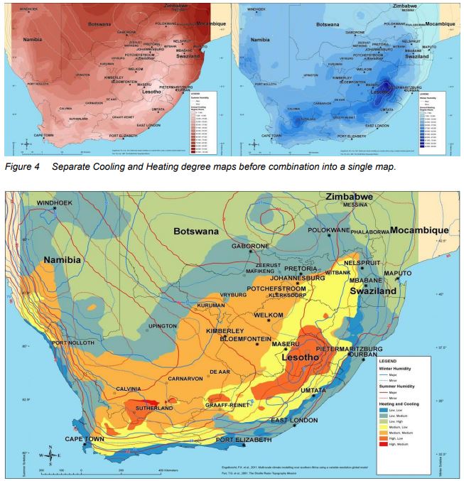
Over the last 100 years, many different heat strain indices have been proposed to indicate comparative thermal comfort levels. After reviewing these standards the team concluded that Standard Effective Temperature (SET), as proposed by Gagge, might be the best index as it considers the effect of humidity in the experience of thermal comfort. SET maps were produced using the same data as had been used to produce the Köppen-Geiger map. Verification of the SET maps showed weak to poor correlations between SET and the expected building heating and cooling energy demands. As a result of the poor correlation, the decision was made to create a set of maps based on interpreted degree days in order to establish if such an index would give a better correlation to building energy demand.
A very large dataset of 21 years of hourly data, which assumes an A2 climate change scenario at a 50 km resolution, was used in the process. An algorithm was used to resample the source data from 50 km to 5 km. This 5 km grid dataset was used to produce heating and cooling degree day maps. An excellent correlation between degrees days and modelled building energy demand was found. This paper describes the data processing, creation of the degree day map and the subsequent verification processes in detail.

Comments