Log in

Create a user profile using your existing professional profile on LinkedIn, Academia, or ResearchGate.


Alternatively, register a username and password to start an account.


By creating an account you will be able to contribute articles, engage in discussion groups, network with fellow professionals and businesses, and receive interest-related alerts.

Forgot Password

Please enter your email address below and you will receive a temporary link to re-activate your account

The applicability of the South African Census 2011 data for evidence-based urban planning

Article image

Sibusisiwe Khuluse-Makhanya, Nontembeko Dudeni-Tlhone, Jennifer Holloway, Peter Schmitz, Louis Waldeck, Alfred Stein, Pravesh Debba, Theo Stylianides, Pierre du Plessis, Antony K Cooper, Ethel Baloyi

30 June 2016

English

Antony Cooper

Journal article

Council for Scientific and Industrial Research

South Africa

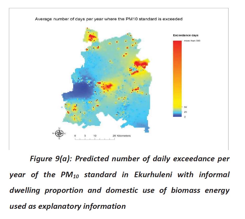
In urban planning, it is important to understand settlements in terms of demographics, socio-economic and location characteristics. A key dataset used for such studies is a national census small area dataset. This paper provides three cases studies using the 2011 South African census small area data to highlight the value added as well as challenges identified in using these data. The data were used to study patterns in housing conditions for urban growth simulation, to determine new school locations in feeder catchments, and to aid air quality mapping. The methods undertaken for these case studies were an adaptation of k-means cluster analysis for distinguishing housing and household patterns in order to identify homogenous areas with similar demands for infrastructure and services; catchment analysis using Flowmap to determine new school locations; and Kriging with external drift to map an indicator of air quality.


In all case studies, the census small area data were critical and the information derived is deemed useful for various urban planning decisions, including planning for the provision of essential services, planning for air pollution control at locations where regulatory levels of pollutants are exceeded frequently, and planning for the development of social infrastructure in areas that are under-serviced.

Downloads

Website References

Air quality

Built environment

Cities and towns

City planning

Climate Change/Resilience

Communities

Community development

Data analysis

Data mining

Demographic surveys

Education

Educational institutions

Geographical information systems

Geomatics

Health

Housing quality

ICT

Land use

Land use mapping

Planning and management

Pollution

Population surveys

Quality of life

Research

Settlement upgrading

Simulation

South Africa

Spatial analysis

Spatial development

Statistical analysis

Urban and Regional Dynamics

Urban areas

View Contributors:

Comments

No comments available
LOAD MORE