
CSIR Settlement-Mesozone Geo-Frame
Dataset Description & Download
Background
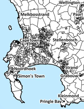
The Settlement-Mesozone Geo-Frame is a nationally consistent spatial framework developed by the CSIR to support evidence-based planning, monitoring and spatial analysis across South Africa.
The geo-frame provides a standard small-area geography that enables the integration and analysis of demographic, economic, social, environmental and service delivery information within a common spatial framework. It was developed to address the limitations of administrative boundaries, which often change over time and may not accurately reflect the spatial structure of settlements and communities.
The dataset supports a wide range of applications, including:
- Spatial profiling of settlements and local areas
- Monitoring settlement growth and development patterns
- Assessing access to services, infrastructure and economic opportunities
- Integrating data from multiple sources within a common geography
- Supporting planning, investment and policy coordination across national, provincial and local government
- Enabling consistent analysis and comparison over time
The geo-frame provides wall-to-wall national coverage across South Africa, representing both settlements and the rural, agricultural and conservation areas between them within a single coherent spatial framework.
Further information on the development, methodology and evolution of the geo-frame is available in the peer-reviewed article: The Settlement-Mesozone Geo-Frame: An evolving spatial data framework facilitating data integration in support of South Africa’s development planning.
Dataset Description
The Settlement Footprint Geo-Frame consists of spatial boundaries and selected demographic and economic indicators integrated from national datasets.
Core Spatial Attributes
- Polygon geometry and spatial extent
- Unique Settlement Footprint identifier
- Settlement hierarchy and aggregation levels
- Settlement typology/classification
- Municipal, district and provincial linkages
Demographic and Economic Attributes
- Total population (All values are expressed as total population count. Downscaled from Stats SA mid-year population estimates for 2024).
- Total economic activity (All values are expressed as Gross Value Added (GVA) in R million constant 2015 prices (ZAR). Downscaled from Quantec’s inflation-adjusted inflation-adjusted RSA Standardised Regional Income & Production: Regional Output and GVA at basic prices dataset for the years 2024).
Temporal Coverage
The current release provides data for 2024 only.
Dataset Version
Settlement Footprint Geo-Frame - Version 1.0 (2024 Base: Framework 2024; Attributes 2024; uKESA Release September 2026).
Citation
The dataset is defined as the "Settlement-Mesozone Geo-Frame" and should always be referenced accordingly.
When using this dataset, please reference it as:
- CSIR (2026). Settlement-Mesozone Geo-Frame. [dataset]. Version 1.0 (2024 Base: Framework 2024; Attributes 2024; uKESA Release September 2026). Pretoria: Council for Scientific and Industrial Research (CSIR) [producer]. Pretoria: uKESA [distributor]. [online] Available at: https://www.ukesa.info/library/view/csir-settlement-mesozone-geo-frame2
The supporting article, describing the development, methodology and evolution of the Settlement-Mesozone Geo-Frame should always be reference with the dataset as:
- Arnold, K.A., Maritz, J. & Mans, G.G. (2026). The Settlement-Mesozone Geo-Frame: an evolving spatial data framework facilitating data integration in support of South Africa’s development planning. International Journal of Cartography, 12(2): 211–229. DOI: https://doi.org/10.1080/23729333.2025.2565838
Download
Download the dataset here (Map Package & Metadata - 85.3 MB)
Contact
For more information, please contact Gerbrand Mans (GMans@csir.co.za), Kathryn Arnold (KArnold@csir.co.za) or Johan Maritz (JMaritz@csir.co.za)


Comments