Smart facility location planning for Smart Cities
Using GIS technology and facility provision standards for pro-active planning of social facilities to support smart growth
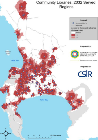
This paper describes a rational approach to the planning of social facility provision to eradicate service backlogs of the current period as well as preparing for the future. For more than a decade a GIS-based methodology has been used in South Africa to assess and plan for the provision of social facilities and to provide input to integrated social facility development plans which are not only defensible but enable smart decision making that impacts meaningfully on investment priorities. This enables the greatest impact from the least number of investment locations to maximise return on investment. To support this work the CSIR has consolidated, refined and adjusted guideline standards that not only specify a provision ratio for each facility but also define a specific distance that should be used to measure accessibility in different contexts.
Planning and implementation flowing from this occurs in an environment full of pressures relating to insufficient resources to deal with the quantum of the development challenge, competing for political and administrative priorities, and critical skills shortages. While not initially driven from a Smart City perspective and currently not enabled by real-time data, the approach can, nonetheless, be seen as a major step toward “smart” planning processes to support smart cities of the future. A case study application in Cape Town is used to illustrate the application of the methodology of spatially matching supply and demand for facilities using GIS tools. These tools make use of guideline provision standards that combine both distance and capacity as an input to the models to achieve spatial alignment of new facility provision investment that can respond timeously to city growth. To date this analysis approach has been used to inform planning for capital budget processes in a number of cities to improve service access that impacts 28% of the South African population.


Comments